sábado, agosto 28, 2010

SOUTHAPTON SHOAL LIGHTHOUSE, CALIFORNIA

Photobucket

Southampton Shoal, a two-mile-long navigational hazard, lies along the eastern side of the shipping channel that runs between Berkeley on the east, and Angel Island and the Tiburon Peninsula on the west. When the Santa Fe Railroad commenced ferry service between Point Richmond and San Francisco around 1900, its ferries often passed dangerously close to the southeast portion of the shoal. The Lighthouse Board realized that vessel traffic to and from the Mare Island Shipyard and points farther inland would also benefit from a navigational aid on the shoal, and so a petition was soon sent to Congress requesting $30,000 for the project. The resulting Southampton Shoal Lighthouse was completed in 1905, adding another beacon to the string of lights that safely led mariners through San Francisco Bay.

Photo Text & Copyright www.Lighthousefriends.com

sexta-feira, agosto 27, 2010

SANTA BARBARA LIGHTHOUSE, CALIFORNIA

Photobucket

The site for the Santa Barbara Lighthouse was selected so that the light could serve the double purpose of a sea coast light and a harbor light. In early 1856, George Nagle of San Francisco arrived in Santa Barbara with his family to build the lighthouse on a mesa roughly two miles west of the harbor. Similar in design to most of the early west coast lighthouses, the Santa Barbara Lighthouse was of the Cape Cod style, with the tower projecting from the middle of the gabled roof.

Nagle, who received $8,000 for his work, used Indian labor and mostly local material to finish the lighthouse within the year. On December 1, 1856, a fixed red light was displayed from a fourth-order Fresnel lens.

The first keeper at the station was Albert Williams. After four years, he grew tired of the lighthouse routine and tried his had at farming nearby. When his replacement left in 1865, the position was again offered to Williams. He declined, but his wife Julia accepted. Since the station did not have a fog signal, Julia was able to maintain the light by herself, while raising three boys and two girls.

Photo Text & Copyright www.Lighthousefriends.com

quinta-feira, agosto 26, 2010

PUNTA GORDA LIGHTHOUSE, CALIFORNIA

Photobucket

A defining feature of the northern California coast is a large bulge that protrudes westward into the Pacific Ocean. Along this bulge are two points, separated by roughly eleven miles, which extend farther west than any other points along the Golden State's lengthy shoreline. The northernmost of these points is Cape Mendocino, and the southernmost is Punta Gorda, Spanish for substantial point.

As ships hugged the California coast traveling northward, it is understandable how several ran aground on Punta Gorda. Between 1899 and 1907, at least eight ships met their end in the area. The initial request for a lighthouse to mark Punta Gorda was made in 1888, but it wasn't until after a fog-induced collision between the SS Columbia and the San Pedro on July 21, 1908, which claimed 87 lives, that congress appropriated funds for the Punta Gorda Lighthouse.

Photo Text & Copyright www.Lighthousefriends.com

quarta-feira, agosto 25, 2010

POINT REYES LIGHTHOUSE, CALIFORNIA

Photobucket

Considered one of the foggiest and windiest stations in the U.S., Point Reyes inspired Lightkeeper E.G.


Photo Text & Copyright www.Lighthousefriends.com

terça-feira, agosto 24, 2010

POINT KNOX LIGHTHOUSE, CALIFORNIA

Photobucket

Photobucket

On top of a small, rocky outcropping, that extends from the southwest corner of Angel Island, sits a wooden platform from which a bell is suspended. The outcropping, known as Point Knox, lies at the base of a steep bluff and today is inaccessible. Few of today's visitors to Angel Island, the largest island in San Francisco Bay, even notice the bell, which makes one question why the bell was left at the point.

Was it simply because the 3,000 pound bell was too heavy to remove easily? Lighthouse enthusiasts prefer to believe that the bell was left as a tribute to a faithful keeper whose service at the Point Knox Lighthouse has become legendary.


Photo Text & Copyright www.Lighthousefriends.com

segunda-feira, agosto 23, 2010

POINT DIABLO LIGHTHOUSE, CALIFORNIA

Photobucket

Photobucket

Point Diablo is located roughly midway between Point Bonita and Lime Point on the northern side of the Golden Gate. The point protrudes some 600 feet into the waters from the Marin Headlands, making the point, according to the Lighthouse Service, "a dangerous menace to vessels entering San Francisco Bay in foggy weather."

In 1923, the Lighthouse Service decided to mark this navigational hazard, and a small white shack with a pitched red roof was placed on the sloping point some eighty feet above the water. The structure housed two lens lanterns and a 12-inch electric siren, for which the keepers at Lime Point were responsible. A telephone and electric line was strung to the point on poles, allowing the Lime Point keepers to listen-in on the semi-automated station. Still, the keepers were required to travel to Point Diablo weekly to clean the light and oil the fog signal.

An array of solar panels now powers the modern beacon positioned atop the shack. The light flashes every six seconds, and when necessary the fog signal alerts mariners to the presence of menacing Point Diablo.


Photo Text & Copyright www.Lighthousefriends.com

domingo, agosto 22, 2010

POINT BONITA LIGHTHOUSE, CALIFORNIA

Photobucket

Guardian of the northern tip of the Golden Gate, the Point Bonita Lighthouse still uses its original second-order Fresnel lens to cast forth a guiding beacon for mariners.

In the 1850s, as lighthouses started popping up along the West Coast, mariners cried for a light to mark the entrance of the Golden Gate whose recalcitrant currents, dangerous shoals, and incessant clinging fog had strangled the journey of many a vessel.


Photo Text & Copyright www.Lighthousefriends.com

sábado, agosto 21, 2010

POINT ARENA LIGHTHOUSE, CALIFORNIA

Photobucket

When traveling north from Point Reyes, the next prominent point along the California coast is reached after sixty-eight miles. Known by early explorers as Punta Barro de Arena, Spanish for Sand Bar Point, the feature is now known simply as Point Arena. Here, the coast changes from running in a northwesterly direction to more of a northerly direction, and as ship traffic carrying redwood lumber from Northern California to San Francisco increased in the 1850s and 1860s, so did the need for a light to mark this critical turning point.

Photo Text & Copyright www.Lighthousefriends.com

sexta-feira, agosto 20, 2010

OLD POINT LOMA LIGHTHOUSE, CALIFORNIA

Photobucket

With the discovery of gold at Sutter's Mill in 1848, ship traffic greatly increased on the west coast, prompting the construction of several lighthouses. The Point Loma Lighthouse was one of the original eight west coast lighthouses, built under contract by the firm of Gibbons and Kelly from Baltimore. Six of the original eight, including the Point Loma Lighthouse, were built in the cape cod style, consisting of a one and a half story dwelling with a central, spiral staircase leading to the lantern room perched atop the structure.

The site selected for the lighthouse was the summit of Point Loma, a narrow finger of land forming the western boundary of San Diego's harbor and protecting it from the Pacific Ocean. On April 7, 1854, following the successful completion of lighthouses on Alcatraz Island, Fort Point and on the Farallon Islands, the schooner Vaquero finally arrived in San Diego with the necessary building supplies for the Point Loma Lighthouse.
First, a road had to be constructed from the harbor to the top of the barren point. Sandstone for the dwelling was quarried on the point, while bricks were used to construct the tower and tiles from the ruins of the old Spanish Fort Guijarros were used for the basement floor. Water, needed for the mortar, had to be hauled from a well located seven miles from the site.


Photo Text & Copyright www.Lighthousefriends.com

quinta-feira, agosto 19, 2010

MILE ROCKS LIGHTHOUSE, CALIFORNIA

Photobucket

The southern side of the entrance to the Golden Gate is dotted with a family of dangerous wave-swept rocks that includes Black Head Rock, Lobos Rock, and Pyramid Rock. The two northernmost, and thus most dangerous to navigation, are Mile Rock and Little Mile Rock, known together as Mile Rocks. Located only 0.4 miles from the closest shore, it seems Mile Rocks are so named because the rocks are one mile south of the main shipping channel leading into San Francisco Bay.

In November of 1889, the Lighthouse Service placed a bell buoy near the rocks. However, the strong currents in the area would pull the buoy beneath the surface of the water and even set it adrift. Frustrated lighthouse engineers concluded that the rocks “must always be a menace to navigation as long as they exist,” as building atop the rocks or dynamiting them below the surface didn't seem practical. Then on February 22, 1901 the City of Rio de Janeiro, inbound from Hong Kong in heavy fog, struck Fort Point Ledge and sunk in just eight minutes. Of the 210 aboard, 128 were lost. The Lighthouse Board concluded that the shipwreck, the worst in San Francisco’s history, might not have occurred if a fog signal could be heard considerably seaward of the ledge.


Photo Text & Copyright www.Lighthousefriends.com

quarta-feira, agosto 18, 2010

LIME POINT LIGHTHOUSE, CALIFORNIA

Photobucket

Photobucket

Lime Point is situated on the northern side of the Golden Gate’s narrowest point. From this point, a rocky spur, just twenty feet wide, extends roughly 100 feet into the bay. In 1833, a narrow one-story fog signal building and a two-story keeper’s dwelling were constructed along the spur.
The fog signal building was positioned closest to the water, so its two twelve-inch steam whistles, powered by coal-fired boilers, could warn vessels away from the rocky hazard. Water for the keepers and the fog signal was tapped at a nearby spring, piped to the station and stored in a 20,000-gallon tank.

Photo Text & Copyright www.Lighthousefriends.com

terça-feira, agosto 17, 2010

FORT POINT LIGHTHOUSE, CALIFORNIA

Photobucket

Photobucket

Fort Point and Lime Point define respectively the southern and northern flanks of the narrow entrance to San Francisco Bay. Given its prime location, Fort Point has been a desired spot for several construction projects over the years. First was a cottage-style lighthouse to mark the entrance. Next was a fort positioned to protect the entrance, and finally came the graceful Golden Gate Bridge to span the entrance. Evidence of the three projects is still visible on the point today. A tiny lighthouse sits perched atop the massive brick fort, which is overarched by the towering bridge.

Photo Text & Copyright www.Lighthousefriends.com

segunda-feira, agosto 16, 2010

CARQUINEZ STRAIT LIGHTHOUSE, CALIFORNIA

Photobucket

In the mid 1800s, ship traffic from San Francisco Bay inland to the Napa, San Joaquin, and Sacramento Rivers increased greatly, due to two main factors: 1) the discovery of gold at Sutter's Mill, which led to a flood of prospectors who often sailed up the Sacramento River en route to the gold fields, and 2) the Navy constructing the first base for its Pacific Fleet at Mare Island, near the mouth of the Napa River.
To reach the rivers, vessels would first sail through the wide San Francisco and San Pablo Bays. At the eastern end of San Pablo Bay, traffic would approach the narrow confines of Carquinez Strait where ships could turn north into the Napa River to reach Mare Island, or continue east through Carquinez Strait and Susuin Bay to reach the Sacramento and San Joaquin Rivers

Photo Text & Copyright www.Lighthousefriends.com

domingo, agosto 15, 2010

ANO NUEVO LIGHTHOUSE, CALIFORNIA

Photobucket

Most visitors today come to Año Nuevo Point to view the elephant seal colony, which takes up residence on the beaches in the area at various periods throughout the year. Those who come to the point to peer out across a half-mile stretch of water to see the toppled tower and dilapidated keepers' dwellings on Año Nuevo Island are definitely in the minority.

Photo Text & Copyright www.Lighthousefriends.com

sábado, agosto 14, 2010

TRINIDAD HEAD LIGHTHOUSE, CALIFORNIA

Photobucket

Trinidad Head, a large domed prominence rising to a height of 380 feet, is connected to the mainland only on its northern end, thus forming the beautiful and natural Trinidad Bay on its eastern side. On the bluffs overlooking the bay, Trinidad, the oldest town on the northern California coast, was founded on April 8, 1850.
Early on, the town was a vital link between ships anchored in the bay and miners testing their luck in the Klamath, Trinity, Salmon River, and Gold Bluff Mines.
As the gold rush slowed, Trinidad Bay, like most bays along the Redwood Coast, became home to multiple sawmills. To aid vessels engaged in the lumber trade, a lighthouse was proposed for the ocean-facing side of the headland in 1854.

Photo Text & Copyright www.Lighthousefriends.com

sexta-feira, agosto 13, 2010

SANTA CRUZ BREAKWATER LIGHTHOUSE, CALIFORNIA

Photobucket

Located at the northern end of the Monterey Bay, the Santa Cruz Harbor is a haven for fishing craft and vessels. A harbor light, located at the west jetty, has marked its entrance for 40 years. The original light was a box light structure which served from 1964 – 1996. It was replaced by a cylinder nicknamed “the water heater” which was used from 1996 – 1999. From 1999 until May 2002, a simple pipe structure held the light which marked the way.

In 1998, the Santa Cruz community proposed replacing the unsightly harbor light with a lighthouse of classic design, adding a little more character to a community renowned for its characters. Fundraising efforts began in earnest, and with the contributions of many people, including a major donation from Mr. Charles Walton of Los Gatos, enough money was raised to begin construction of the new lighthouse in 2001.

The lighthouse, designed by Mark Mesiti-Miller and constructed by Devcon Construction, Inc., stands 41 ½ feet tall above the level of the west jetty, and 59 ½ feet above the mean low water mark. It weighs 350,000 pounds and is built to withstand a quarter million pounds of wave energy.

The construction began with a cylindrical inner core which houses electrical equipment and a circular staircase of 42 steps which lead to the top of the lighthouse. Surrounding the inner core is a network of reinforcement rods, onto which “shotcrete” was blown and then hand-troweled to form the conical shape. These shotcrete walls are 4 ½ feet thick at the base. Finally, a durable weatherproof white finish was applied to the exterior of the lighthouse and a copper roofed lantern room topped it all off.

On June 9, 2002, the new harbor lighthouse was dedicated, and the signal, a green light flashing every four seconds at a focal plane of 36 feet, was activated. It is named the Walton Lighthouse, in honor of Mr. Charles Walton’s late brother, Derek, who served in the merchant marines.

As shown in the top two pictures at the left, which were taken in November 2002, the lighthouse originally had a red band day mark. In March 2003, the day mark was changed to a green band, after boaters protested that a green beacon should not have a red day mark. The green band can be seen in the bottom photograph.


Photo Text & Copyright www.Lighthousefriends.com

quinta-feira, agosto 12, 2010

SAN LUIS OBISPO LIGHTHOUSE, CALIFORNIA

Photobucket

Under the shelter of Point San Luis, on the southwestern shore of San Luis Bay, John Harford completed a 540-foot-long pier in 1873, and then extended it to 1500 feet in 1876. A 30-inch narrow gauge railroad ran along the wharf and eventually tied the harbor, then known as Port Harford, to San Luis Obispo and other Central Coast communities. Port Harford became a vital link for transporting both passengers and commerce to and from the area.

Photo Text & Copyright www.Lighthousefriends.com

quarta-feira, agosto 11, 2010

POINT VICENTE LIGHTHOUSE, CALIFORNIA

Photobucket


The Palos Verdes Peninsula is the most prominent coastal feature between Point Loma to the south and Point Conception to the north. When Captain George Vancouver sailed along its shores in 1793, he named the southwest tip of the peninsula Point Vicente, in honor of his friend, Friar Vicente of the Mission San Buenaventura.

Despite the point's prominence, funding for a lighthouse to mark this turning point into the harbors of San Pedro and Long Beach was not approved until 1916, when Congress appropriated $80,000 for a light and fog signal. Delays in acquiring the eight-acre parcel of land postponed construction until 1925. A United States district attorney had prepared data for a condemnation suit for the desired parcel before the land company made a satisfactory offer to the government.

The site on the point was fully acquire in 1922, but the fog signal was not activated until June 20, 1925, and the light atop the 67-foot cylindrical Point Vicente Lighthouse was not exhibited until April 14, 1926.


Photo Text & Copyright www.Lighthousefriends.com

terça-feira, agosto 10, 2010

POINT PINOS LIGHTHOUSE, CALIFORNIA

Photobucket

While on an expedition in 1602 for the Count of Monterrey, Spanish explorer Sebastian Vizcaino named the point at the southern entrance to Monterey Bay Punta de los Pinos, Point of the Pines, a fitting name for the tip of the Monterey Peninsula with its covering of Monterey Pines.

Photo Text & Copyright www.Lighthousefriends.com

segunda-feira, agosto 09, 2010

POINT HUENEME LIGHTHOUSE, CALIFORNIA

Photobucket

Hueneme (pronounced "why-nee-mee") is derived from a Chumash Indian word meaning "half-way" or "resting place." It is believed that Indians stopped at Point Hueneme as they transited between today's Point Mugu and the mouth of the Santa Clara River. Point Hueneme and Anacapa Island, located twelve miles offshore from the point, define the southern entrance to the Santa Barbara Channel. A sum of $22,000 was allocated by Congress on March 3, 1873 for a lighthouse to mark Point Hueneme. Remote Anacapa Island would have to wait until 1912 to receive its first light.

Photo Text & Copyright www.Lighthousefriends.com

domingo, agosto 08, 2010

POINT CONCEPTION LIGHTHOUSE, CALIFORNIA

Photobucket

Photobucket

Photobucket

Most of the California coast runs in a general north-south direction, but along the Santa Barbara channel, it changes to more of an east-west direction. At the western end of this channel, the coast makes an abrupt 90-degree turn northward. This transition point, which some early explorers termed the Cape Horn of the Pacific and where mariners following the coast have to make a severe course correction, was the site selected for the Point Conception Lighthouse.

Photo Text & Copyright www.Lighthousefriends.com

sábado, agosto 07, 2010

POINT BLUNT LIGHTHOUSE, CALIFORNIA

Photobucket

In 1775, Juan Manuel de Ayala became the first European navigator to sail into San Francisco Bay. He found a protected anchorage in a small cove on the northern side of the bay's largest island and promptly named the island "Isla de Nuestra Senora de Los Angeles" or in English, "Island of Our Lady of the Angels." The name stuck, though later shortened to simply Angel Island. Angel Island's cove, where passengers now disembark to visit the island, is called Ayala Cove in honor of the early explorer.

Photo Text & Copyright www.Lighthousefriends.com

sexta-feira, agosto 06, 2010

PIGEON POINT LIGHTHOUSE, CALIFORNIA

Photobucket

The Carrier Pigeon, a 175-foot long clipper ship with a gilded pigeon as her figurehead, was launched from the shipyards at Bath, Maine in the fall of 1852 and left Boston on January 28, 1853 for her maiden voyage around Cape Horn to San Francisco.
On the morning of June 6, the vessel was spotted off Santa Cruz, but visibility worsened and shrouded the ship in a thick blanket of fog as the day progressed. That evening, the captain, believing he was a good distance from land, steered his vessel shoreward. Before land was sighted, the Carrier Pigeon struck rocks and quickly began taking on water.
The captain and crew made it safely to shore, but the ship was a loss. After offloading a good portion of the supplies, the vessel, valued at $54,000 and still stranded on the rocks, was sold for $1,500. Since the time of the wreck, the point of land closest to the rocks that claimed the Carrier Pigeon has been called Pigeon Point.
Previously, the point had been known as Punta de las Ballenas (Point of the Whales) as a whaling station was located nearby.

Photo Text & Copyright www.Lighthousefriends.com

quinta-feira, agosto 05, 2010

OAKLAND HARBOR LIGHTHOUSE, CALIFORNIA

Photobucket

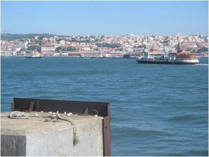
The arrival of the Central Pacific railroad terminus at Oakland in 1869 heightened the need for a nearby link to shipping in San Francisco Bay. Consequently, two piers that were spaced 750 feet and extended two miles out into the bay were built, and the area around them was dredged to form a shipping terminal.

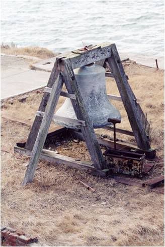
The original Oakland Harbor Lighthouse sat on eleven wooden pilings, which had been driven into the bottom of the bay off the end of the northern pier. The lighthouse was similar in style to several of the original California lights with a central tower that extended through the gabled roof of a rectangular, two-story dwelling. The lantern room housed a fifth-order Fresnel lens, and the station was activated on January 27, 1890. A fog signal for the station, in the form of a 3,500-pound bell, was mounted on a wooden walkway that encircled the dwelling. The bell, which caused the lighthouse to shudder when it was struck every five seconds, was located just ten feet from one of the keeper’s beds. Adjacent to the bell was a water tank for storing rainwater captured on the dwelling’s roof.

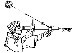
As the station was surrounded by open waters, the keepers had to rely on a small rowboat to obtain supplies and tend the light on the south pier. One morning, the Southern Pacific Railroad’s 294-foot side wheel paddle ferry Newark paid an unannounced visit to the station. Keepers Charles McCarthy and Hermann Engel were on duty, when Engel’s wife spied the ferry heading directly towards the station. The Newark smashed one of the lighthouse’s support piles and a platform brace, but nobody was hurt in the incident. The enraged captained yelled at the keepers while backing his vessel away, even though he was clearly at fault.

After just over a decade of operation, marine borers had weakened the wooden pilings under the lighthouse, and rocks quarried near the lighthouse depot on Yerba Buena Island were brought in to try to stabilize the foundation. By 1902, the stability of the light was questioned, and the Lighthouse Board decided to build a larger structure nearby. This time, huge concrete-filled steel support cylinders with a diameter of four feet were used to thwart the marine borers.

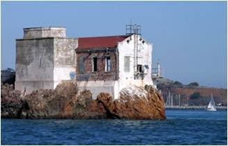
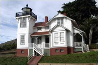
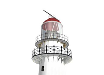
The second lighthouse was a nearly square, two-story structure built upon a steel beam decking that rested on the support cylinders. The bottom floor of the lighthouse was used primarily for storage, while the upper floor was home to two keepers and their families. From each of the four walls, the roof sloped upward to a short square tower located at its center. The new lighthouse commenced operating on July 11, 1903, with the fog bell from the original lighthouse mounted on the second story’s balcony.

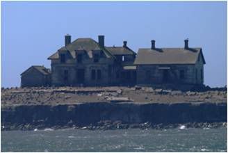
After the completion of the new lighthouse, its predecessor was declared a navigational hazard and had to be removed. In February of 1904, the old lighthouse was auctioned off, and the winning bidder was required to remove the entire structure, including the support pilings, within thirty days. The local press bemoaned the loss of the familiar lighthouse: “For many years this has been the guide of the night ferries, and during storm and fair weather, fog and moonlight, it has shone steadily and lighted the deep-sea liner in and the crawling bay scow schooner by. … The passing of the old light will be a source of regret to all lovers of the Bay, as it has grown into the affections of the constant user of it. This harbor light was the one to which the Oaklander’s eye always turned on the night ferry, and its merry gleam lighted many a happy party on yachting back to port.”

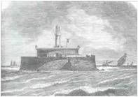
As commerce in the area grew, the Western Pacific Railroad’s ferry slip was extended to encompass the lighthouse. The Coast Guard photograph at right shows the wooden lighthouse, enclosed in the end of the pier. The pier extension simplified life for the keepers, as they could now reach the lighthouse by foot or car, rather than the station's rowboat. Transcontinental railroad connections were also now available for the keepers just a few steps from the door of the lighthouse.

Although the keepers lives were certainly simplified by the pier extension, their jobs were still demanding and even dangerous. On August 26, 1923, a stiff west wind caused a fisherman’s skiff to capsize just off the northern pier. Keeper Charles H.A. Brooke witnessed the mishap and quickly went to the rescue of the floundering fisherman. Brooke’s effort was later praised in the “Lighthouse Service Bulletin.”

Myron Edgington was in charge of the Oakland Harbor Lighthouse in the 1950s. By this time, the Coast Guard had taken control of the country’s lighthouses, so Edgington’s assistants were two Coast Guardsmen. Edgington had served in the Navy and at the Mile Rocks and Point Vicente Lighthouses before accepting a transfer to Oakland. In his spare time, Edgington practiced the old seafaring craft of macramé, making beautiful mats and tablecloths for the station. Keeper Edgington and his two assistants received their chance to perform a rescue operation when two Navy fliers, likely from the nearby Naval Air Station Alameda, plunged into the water near the lighthouse.

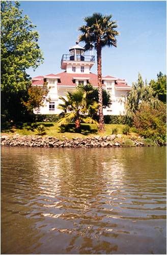
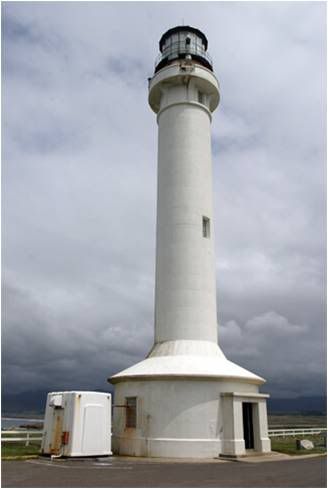
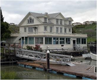
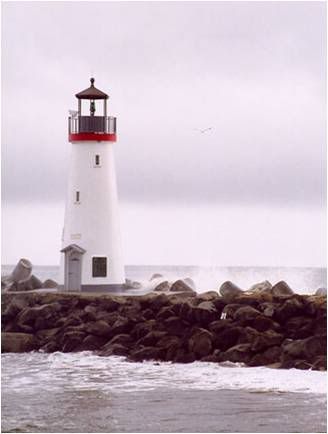
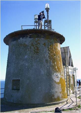
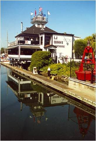
In 1966, an automatic beacon was installed near the lighthouse, and the lighthouse was deactivated. Shortly thereafter, the lantern room was shipped to Santa Cruz were it was installed on the recently constructed Mark Abbott Memorial Lighthouse. The Oakland Harbor Lighthouse was eventually sold to a restaurant firm for $1, but the new owners then had to spend $22,144 to have the Murphy-Pacific Corporation transport the edifice six miles south along the Oakland estuary to its current home at Embarcadero Cove, where it was converted into Quinn's Lighthouse Restaurant and Pub. The restaurant has been open since 1984 and features “contemporary American cuisine.”


Photo Text & Copyright www.Lighthousefriends.com

quarta-feira, agosto 04, 2010

LOS ANGELES HARBOR LIGHTHOUSE, CALIFORNIA

Photobucket

The Los Angeles Harbor Lighthouse, also known as the "Angel's Gate" light, welcomes ships into the harbor of the City of Angels, Los Angeles. Don't let the name confuse you, Los Angeles Harbor is nowhere near downtown Los Angeles, but is located in San Pedro several miles south of the city's cluster of skyscrapers. The lighthouse, completed in 1913 at a cost of just under $36,000, was built around twelve steel columns and sits at the end of the 9,250-foot San Pedro breakwater. The bottom of the lighthouse is octagonal, while the top three stories are cylindrical. The twelve columns, now covered with black pilasters, give the lighthouse a Romanesque feel. No other lighthouse was ever built to this design.

Photo Text & Copyright www.Lighthousefriends.com

terça-feira, agosto 03, 2010

FARALLON ISLAND LIGHTHOUSE, CALIFORNIA

Photobucket

Thirty miles west of San Francisco a collection of small, rocky islands is found. Discovered by Spaniards, the islands were given the name Los Farallones, which means small, pointed isles. The name of the islands has now been Americanized to Farallon Islands. The largest and tallest of the islands is southeast Farallon, which rises to a height of 358 feet. It was atop this island that the Farallon Island Lighthouse was constructed.


Photo Text & Copyright www.Lighthousefriends.com

segunda-feira, agosto 02, 2010

NRP TRIDENTE, BEM VINDO

Photobucket

Photobucket

Photobucket

Photobucket

Bem Vindo Nrp Tridente!!
Cerca das 09:55 da manhã passou sob a Ponte 25 de Abril, o novo navio da Marinha de Guerra Portuguesa.
O novo submarino Nrp Tridente...
Sempre escoltado por um helicóptero da Marinha Portuguesa, por alguns rebocadores, lançando jactos de água, assim como algumas embarcações civis e antigas faluas recuperadas.
Se fosse fim de semana, não tenho dúvidas que a recepção seria uma coisa gigantesca e bem á medida, porque os nossos marinheiros, estão sempre á espreita de motivos para navegar.
Ainda bem!
A zona ribeirinha de Cacilhas e até mesmo o Pontal de Cacilhas, estava repleto de fotógrafos amadores e não só, para tomarem nota deste evento.
Text Photo & Copyiright Luis Villas

CAPE MENDOCINO, CALIFORNIA

Photobucket

Photobucket


Cape Mendocino is the westernmost point in California, just beating out Punta Gorda eleven miles to the south. Standing just offshore from the mountainous headland of Cape Mendocino is Sugar Loaf, a 326-foot sea stack. Several other large rocks protrude from the shallow waters along this stretch of coast, hinting that hidden ledges might lie just below the surface of the ocean waiting for a misguided vessel. That they do indeed exist is evidenced by dangerous Blunt's Reef located three miles off the cape.

On September 14, 1867 the lighthouse tender Shubrick was steaming towards Cape Mendocino loaded with men and supplies for construction of the station. Thirty miles south of Punta Gorda the side-wheeler tender struck a rock, puncturing her wooden hull. The ship's captain wisely chose to run her aground to save the vessel from sinking. The tender was salvaged, but all supplies were lost. A few months later, new supplies were successfully landed at the base of the headland at Cape Mendocino and hauled up the steep slope to the construction


Photo Text & Copyright www.Lighthousefriends.com

domingo, agosto 01, 2010

ANACAPA ISLAND, CALIFORNIA

Photobucket

Anacapa Island is actually a chain of three small islands, located twelve miles off the California coast and linked together by reefs that are visible at low tide. The islands are named appropriately East, Middle and West Islands. West Island, the largest island of this group, is two miles long by six tenths of a mile wide, and rises to a peak of 930 feet. Middle Island is one and a half miles long, a quarter of a mile wide and 325 feet at its highest point. East Island is a mile long, a quarter of a mile wide, and rises to an elevation of 250 feet. Just off the eastern end of East Island is a forty-foot-high natural bridge, named Arch Rock, which is a trademark for Anacapa and Channel Islands National Park.

Photo Text & Copyright www.Lighthousefriends.com