terça-feira, setembro 30, 2008

SUNRISE

Photobucket

Photo & Copyright Viji

segunda-feira, setembro 29, 2008

AUSTRALIA

Photobucket

Photo & Copyright Wade

domingo, setembro 28, 2008

ESPERANDO A HORA DA FAINA

Photobucket

Photo & Copyright Alex

sábado, setembro 27, 2008

BARCO ABANDONADO EM FIM DE VIDA

Photobucket

Photo & Copyright Tom

sexta-feira, setembro 26, 2008

MARE NOSTRUM

Photobucket

Os Romanos antigos sempre priveligiaram a solidez da terra à inquietude das águas. A primeira batalha naval entre os Romanos e os Cartagineses (260 AC) foi vencida pela frota Romana graças à inovação e tática engenhosa.
Desde então os Romanos tornaram-se os dominadores indisputaveis do Mar Mediterrâneo, rapidamente logo se transformou em um tipo de 'Lago particular' e consequentemente renomeado por eles como 'Mare Nostrum' ('Nosso Mar'), infinitamente mais seguro e hospitaleiro que o Oceano desconhecido além dos Pilares de Hercules.


Photo & Copyright Tom
Texto : Sound of Silence - http://loja.soundofsilence.com.pt/epages/193169.sf/pt_PT/?ObjectPath=/Shops/193169/Products/%22IRM%20862%22

quarta-feira, setembro 24, 2008

TALL SHIPS

Photobucket

Photo & Copyright Tomek

terça-feira, setembro 23, 2008

REGRESSO A CASA

Photobucket


Photo & Copyright JM

segunda-feira, setembro 22, 2008

NAVEGANDO NO ALASKA

Photobucket


Photo & Copyright David

domingo, setembro 21, 2008

sábado, setembro 20, 2008

UM FAROL AO PÔR DO SOL

Photobucket

Photo & copyright Wendy

sexta-feira, setembro 19, 2008

LIGHTHOUSE IN THE DARK

Photobucket

Photo & Copyright Stephane

quinta-feira, setembro 18, 2008

LIGHTHOUSE OF NEW ZEALAND : BARING HEAD

Photobucket

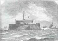
In 1929 the Marine Department discussed moving the old Pencarrow lighthouse to a new site at Baring Head. The idea was deferred while tests were made on new revolving light equipment at Egmont lighthouse. In 1931 they decided to build a new lighthouse and the contract was let, but due to economics the contract was then deferred. The land was donated by Mr. Eric Riddiford in 1932 and in 1934 work had begun.

First lit on June 18, 1935, Baring Head was the second to last manned lighthouse to be built in New Zealand.

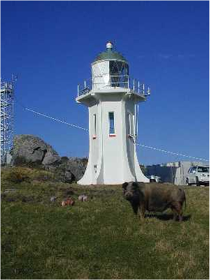
Located on the eastern entrance of the Wellington Heads it also replaced the first New Zealand light, the original
Pencarrow lighthouse which was extinguished and designated as a historical place. The light was the first to run on electricity from the onset and was initially run with a diesel powered generator. This meant the keepers no longer had a night watch and an alarm system in the keeper's house would warn of any failures.

In 1950 the light station was connected to the main electrical grid and the diesel generators were used as a backup.

One of the more accessible lighthouses, the keepers were able to pick up their supplies in Wellington or the suburbs and the keeper's children also attended school there.
During the Second World War the lighthouse was used by the New Zealand Navy as a radar and signal station.

In 1956 the light's character was changed from flashing three times every 15 seconds to the present character due to a nearby Harbour Board automatic light having a similar character.
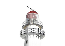
The lens does not revolve, the bulb flashes on and off instead.
The lighthouse was automated in 1989.
The light is viewable from the Cook Strait ferry.
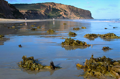
From Wellington drive east to Wainuiomata, then follow the Coast Road south to the beach where there is parking. From there I walked along the beach for views of the light. You will need to cross a river which can be swift and deep as you walk up the beach for closer views of the light.
About a kilometre back up the road there looked like there maybe a walking track up the hill to the light but unfortunately I had run out of time so didn't investigate that option.
Seek permission before using this track as it maybe private land/restricted area.
The drive from Wellington is about 40 km.

Island - North
Province - Wellington
Location - Wellington Heads
Number - K4004
Date Commissioned - 18 June, 1935
Date Decommissioned -
Automated - 1989
Latitude - 41° 25' South
Longitude - 174° 52' East
Elevation Above Sea Level - 87m
Height - 12m
Character - Occulting white light flashing for 9 seconds out of each 15 seconds.
Range - 19 N. miles (35 km)
Made -
Construction -
Converted Kerosene To Diesel -
Converted Diesel To Mains Electricity - Built with a diesel generator. Connected to mains electricity in 1950
Wattage -
Present Tower - Original
Authority - Owned and operated by Maritime Safety Authority
Date Visited - 20 February, 2000


quarta-feira, setembro 17, 2008

LIGHTHOUSE OF GERMANY : MANFRED FUCHS

Photobucket

Lighthouse on the "Dornbusch" For more than 100 years the famous landmark at the island Hiddensee is the Lighthouse at the north of the island. The "Leuchtfeuer Dornbusch" - this is the correct name - was build in the years 1887 / 1888 on a 72m high hill on the island. The original tower was a round building out of bricks an 28 m in size. But in time the building got cracks and so it got a jacket out of ferro-concrete.


Photo & Copyright KAPER - Kite Aerial Photography E-Resources

terça-feira, setembro 16, 2008

UM FAROL NA COSTA DA IRLANDA

Photobucket

Photo & Copyright Franz

segunda-feira, setembro 15, 2008

DE BORDO PARA O MAR

Photobucket

Photo & Copyright Florin

domingo, setembro 14, 2008

UM FAROL NUBLADO

Photobucket

Photo & Copyright Dan

sábado, setembro 13, 2008

O FAROL A BOMBORDO

Photobucket

Photo & Copyright Cristopher

sexta-feira, setembro 12, 2008

quinta-feira, setembro 11, 2008

LIGHTHOUSE OF DENMARK : AGGER TANGE

Photobucket

Lighthouse Agger Tange in May 2006. The steel lattice rear light which belongs to it stands directly at the street 181, about 2,5 kilometres away from the ferry which crosses the Thyborøn Channel. From the rear light a path leads through the dunes to the little red front light. But we have choose a way to the front light a little bit more to the north, from there a street leads to a parking place of an official beach. But also from this parking place we had to go some hundred metres along the beach to the little lighthouse. The little pier light of Thyborøn is located directly opposite at the western side of the Thyborøn Channel.
coordinates (GPS) : 56°42'58.8''N - 08°14'06.5''E


Lighthouses of Anke and Jens
http://www.leuchtturmseiten.de/home.htm?5010

domingo, setembro 07, 2008

LIGHTHOUSE OF USA : BEAVERTAIL LIGHT

Photobucket

The southern tip of eight-mile long Conanicut Island had a watch house marking the entrance to busy Narragansett Bay by1705.
Starting around 1712, a pitch fire was maintained by local Indians, under orders from the Jamestown Town Council.
A fog cannon was established at Beavertail in 1719, about the same time one was installed at Boston Light.
The original 58-foot wooden lighthouse built in 1749 was financed by a tonnage duty on ships trading in the area. The first keeper was Abel Franklin, who was paid $160 yearly.

The tower burned down in 1753 and was rebuilt. It was then burned by the British, who removed some of the lighting apparatus, in 1779. Some of the lighting equipment reportedly made it back into some New England lighthouses, including Rhode Island's Point Judith Light.
In 1838, an inspection by Lieut. George M. Bache reported that Beavertail Light was 64 feet high and 98 feet above sea level, with the light visible for 15 3/4 nautical miles.


Photo & Copyright Jeremy D'Entremont 2007
http://lighthouse.cc/beavertail/history.html

quinta-feira, setembro 04, 2008

UMA PRAIA NO EGIPTO

Photobucket

Photo & Copyright Agata

segunda-feira, setembro 01, 2008

LIGHTHOUSE OF HOLLAND : AMELAND

Photobucket


Latitude ... 53° 26" 43'
Longitude ... 5° 37" 23'
Format ...
DD DMS
Body of water ... Waddenzee
Height Above Water ... 190 feet
Light Characteristics ... Fl W. (3) 15s, visible for 20 nautical miles
Address ... Friesland province, northern coast of Netherlands Hollum, Netherlands


http://marinas.com/view/lighthouse/527